New OpenTopography Feature: Bulk DEM Download
Jul 17, 2009
OpenTopography is pleased to release the LiDAR point cloud portion of the GeoEarthScope Intermountain Seismic Belt data set.
In our ongoing effort to improve the ability to visualize and interact with outputs from the OpenTopography custom digital elevation model system, we have now made it possible to view the hillshade products directly in Google Earth without leaving the browser. Now, in addition to the hillshade browse images and Google Earth KMZ files, you'll see a link to "View KMZ file in Browser" on your results page.
Earth science educators at the community college and undergraduate level are invited to participate in a workshop to be held at the San Diego Supercomputer Center, August 5-7, 2009 on utilizing high-resolution topography and the OpenTopography Portal in the classroom.
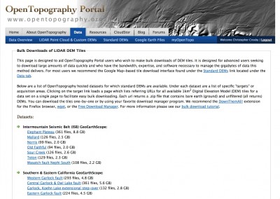
We are pleased to announce the availability of new GeoEarthScope airborne LiDAR data products from the Intermountain Seismic Belt (ISB) project! This release includes high resolution LiDAR topography data collected in tectonically active regions of Utah and Wyoming, including Yellowstone and Grand Teton National Parks and the Nephi segment (southern strand) of the Wasatch fault. These LiDAR data can be explored and downloaded in several ways:
NSF has issued a press release highlighting their recent funding in support of cloud computing activities (via the NSF Cluster Exploratory (CLuE) program).
OpenTopography has released the final round of Northern California GeoEarthScope point cloud data. This release means that all point cloud and tile DEMs for the Northern California data set are now available for download via OpenTopography. New regions available in this release include:
A feature article entitled Illuminating Northern California’s Active Faults appeared in the February 17, 2009 issue of Eos, Transactions of the American Geophysical Union. The article highlights northern California GeoEarthScope LIDAR topography as well as access to those data via the OpenTopography Portal.
OpenTopography has released another batch of Northern California GeoEarthScope point cloud data. This release means that in addition to the full set of tile DEMs and the Google Earth-viewable hillshades, approximately 85% of the Northern California LiDAR point cloud data are accessible via OpenTopography. New regions available in this release include: